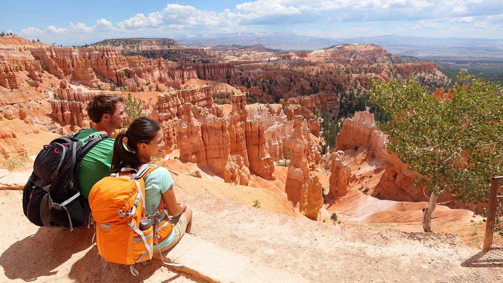
Bryce Canyon National Park offers a wide variety of hikes, from easy out-and-backs you can do with your whole family, to heart-pounding hours on a steep slope. The National Park is famous for its panoramic views of geographical formations called hoodoos.
A hoodoo is a column of weathered rock. In the Canyon, they are frequently topped with a harder piece of stone that has stayed large compared to the lighter sandstone holding it up. Bryce Canyon is full of these, and they are what make it a geographical wonder.
Rim Trail
- Length : 5.5 miles
- Difficulty : Moderate
- Estimated Time : 2 to 4 hours
- Best Time : April through October
The Rim Trail is one of the most iconic trails in Bryce Canyon National Park. It takes you around some of the best viewpoints in the area, including Sunrise Point, Sunset Point, Inspiration Point, and Bryce Point.
To access the trail, you can head to any of these for shorter versions of the hike. Otherwise, drive to the turnoff for Fairyland Point. Park in the lot marked out for it and begin your hike by walking east. It passes by all the scenic overlooks and is one of the Park trails that shouldn’t be missed if you want to get the most out of your trip.
Break up the hike into smaller segments if you have more days and need longer rest periods. There are wooden benches placed at a variety of points along the way or you can bring a backpacking chair.
Mossy Cave Trail
- Length : 0.8 miles
- Difficulty : Easy
- Estimated Time : 20 to 40 minutes
- Best Time : April through October
The Mossy Cave Trail gives you a first glimpse at Bryce Canyon, a good choice if you do not have a lot of time or need an easy trail. It gives you a slice of the Park without having to travel too far inward where crowds of people wait.
To get to the trailhead, drive down UT 12 east until you arrive about 1.2 miles west of the park’s eastmost entrance. It features a short stroll away into the reddish pinnacles that Bryce Canyon is so famed for.
There is a stream here that pioneers had diverted from the Sevier River. It follows this stream more and less. In the end, you come upon a cave filled with moss and cool air. In the winter, there are impressive icicle gardens in the cave.
Fairyland Loop Trail
- Length : 8 miles
- Difficulty : Moderate
- Estimated Time : 3 to 5 hours
- Best Time : April through October
Even the name Fairyland Loop gives you a bit of an idea of this hike’s views and feelings. It takes you past the iconic amphitheater north of Bryce Canyon to see many unique geographic formations.
Fairyland Loop is easy to do as a day hike, although it is best to get an early start since it can get hot and quite crowded during the peak season. Some signs take you to Fairyland Point Overlook. Continue to drive east for about one mile to park in the trailhead lot.
It is easiest to access this trail from Fairyland Point. You can get to it from Sunrise Point by combining it with a short stretch of the Rim Trail. It is located close to the Bryce Canyon Visitor Center and the park entrance that many people drive by and miss the rewarding views. Hike past formations like Sinking Ship and many more.
Peek-A-Boo Loop
- Length : 5.2 miles
- Difficulty : Moderate to hard
- Estimated Time : 3 to 4 hours
- Best Time : April to October
The Peek-a-boo loop is a heavily trafficked trail. It features one of the rivers that run through the Canyon in the primary part of the park. It is one of the more popular hikes in the park and is also used as a horse trail throughout most of the year.
Starting at the beginning of the trail, you take a steep descent into the Bryce Canyon Amphitheater. It is at this point you pass through and past massive hoodoos, getting to appreciate their actual size.
The hike is considered quite strenuous because of this descent and ascent later on, with more than a 1,500 elevation gain so be sure to have supportive hiking boots to protect your ankles.
The Wall of Windows is one of the best features of this hike. A variety of arches mixed with cracks at the top connect hoodoos and frame the sky behind it.
Queen’s Garden & Navajo Loop
- Length : 2.6 miles
- Difficulty : Easy
- Estimated Time : 1 to 2 hours
- Best Time : April through October
The Queen’s Garden, combined with the Navajo Loop, is the most popular hike throughout the entirety of Bryce Canyon National Park. It takes you on an easier walk throughout some of the park’s most breathtaking sections, along the rim and through canyon ridges.
You only gain in elevation about 600 feet throughout the entire hike, making it easy enough that a family can easily take it on. The length of the trail can lead to it being classed as a moderate hike instead.
Many people agree that the best way to do the hike is to start from Sunrise or Sunset Point and work your way in a clockwise direction. The trail descends into the canyon via the Queen’s Garden Trail, and each turn presents a more spectacular view than the last, all of which you will want a camera for, kept safe with a hiking camera backpack.
Inspiration Point
- Length : 0.6 miles
- Difficulty : Easy
- Estimated Time : 15 to 30 minutes
- Best Time : April through October
Inspiration Point is a very short hike that takes you to three different overlooks. It is a hike still worth mentioning, especially if you are looking to do several shorter walks or another combination while visiting the park.
Inspiration Point has a lower, mid, and upper overlook, all of which are heavily trafficked. It is argued that these offer the best viewpoints in the entire park. It also helps that all skill levels can easily do it.
The Lower Point is right next to the parking area. Both the Mid and Upper Overlooks are only short minutes worth a walk from here and are worth doing to soak it all in.
To get there, drive along the Bryce Point Road in the National Park after coming through the entrance. Take the UT-63 to get there and then turn off at the place marked Inspiration Point. Since it is so popular, it is well marked, and you won’t miss it.
Bristlecone Loop Trail
- Length : 1 mile
- Difficulty : Easy
- Estimated Time : ~1 hour
- Best Time : April to November
Bristlecone Loop Trail is another heavily trafficked loop in the trail. There are multiple options to consider when figuring out what you want to do. All of them are considered to be relatively easy compared to most trails. The elevation gain is only about 90 feet throughout the whole hike, meaning it is suitable for even a pair of hiking sandals.
To access the loop, drive to Rainbow Point, which is at the National park’s southern end. It takes you through a forest that is located in the highest part of the park. The elevations here reach 9,100 feet.
The biggest allure of this trail is the Bristlecone pines scattered across this portion of the Park. These trees in the forest include Blue Spruce, White Fir, and the Douglas Fir. There is a lot of wildlife that make their home in these trees. The trees themselves can be up to 1,800 years old. Imagine what they have seen over the millennia.
Fairyland Trail
- Length : 3.4 miles
- Difficulty : Moderate
- Estimated Time : 2 to 4 hours
- Best Time : March through October
If you want to get the chance to see some of the beautiful vistas and geographic interests provided by the Fairyland Trail, but don’t have time or energy for the whole thing, try this one. Tower Bridge is one of the primary features of the trail, and you have the option to do an out and back hike to get to it.
Since the Fairyland Trail is quite popular, you can find yourself among quite the crowd in the peak season. Since it is located so close to the park entrance, it is accessible throughout most of the year. Try going during the spring or late fall to beat the crowd.
The Tower Bridge is a bridge-like arch formation in between two stone pillars. It is majestic and well worth the hike. You also pass by some of the ancient bristlecone pines on your way to it, and other exciting hoodoos and arches.
Under the Rim Trail
- Length : 4 miles
- Difficulty : Moderate
- Estimated Time : 2 to 4 hours
- Best Time : April to October
The Hat Shop is a location you can reach when you hike part of the Under the Rim Trail. Since the trails along the park’s rim are much more popular, you can find some more peace here during the busiest seasons.
The Hat Shop is named because of the bleached white rocks that perch from the top of bright red hoodoos. Altogether, it looks like a collection in an eclectic hat shop represented in nature.
This trail does not offer some of the more iconic views of the park. It makes it an appropriate choice for hikers that have checked most of these off their list but still want to spend some time in the sun. It is also a thigh-buster, so you need to be in relatively good shape to best the elevation gain of more than 1,000 feet. Stay hydrated and bring a water bottle.

Amanda Williams
Amanda Williams is a writer, plant-nerd, and outdoor enthusiast. She has traveled extensively, around the U.S., throughout Asia, Europe, and Latin America. Everywhere she treks, she takes time to enjoy the outdoors. John Muir is her hero. She aspires to inspire people to live better as he did.